vdj7

To many ads? Support ODJT and see no ads!
How do you think on star provides you with gps turn by turn driving instructions? Or how does it know when your airbags have been deployed in an accident and the location when you have benn in an accident? It doesn't work on sat tower like your phone does. It has dedicated sats of its own just like your garmon does. Garman does not use sat towers, it uses sats directly. Thats why they work when your so far off grid you phone doesn't get a signal but your garman still does. My garman uses a max of 5 sat links but can work with a minim of 3 sats to triangulate your location.
You try driving in places where you don't get a phone signal and your phone doesn't work, but your garman does still work and your on star still works.. Your phone is limited to the amount of wattage it can transmit because it's been shown to cause brain damage. On star and garman are not because there not held next to your head, They use higher power wattage so the can work with a sta directly because the use more power. But go ahead and refuse to believe me that thats how it works. Thats your loss, not mine.
I was a over the road truck driver and I have been so far off grid phones don't work but on star and garman gps still does. I've driven every state in the lower 48 and Mexico, and Canada where cell service does not exist because there are no towers close enough to work, but garman gps still does.
And yes cops can use on star to shut your car down. yes they have to use extrema measures but they can and do still use it.

Ever hear of a sat phone? It doesn't use cell towers, It's a direct link to a sat. They would issue us them when I worked for western oil and we were so far off grid regular cell phones wouldn't work.
I worked for my cozen that had a trucking company that all we did was ship bank vaults, safe deposit boxes and sensitive financial documents to banks all over the US we used sat phones along with police radios and undercover police escorts. The trucks were equipped with 1000 gallon fuel tanks on each side with 20 foot sleepers and we ran 3 team drivers. One would drive, one would navagate, and the other would be sleeping. We never stopped for anything. You drove 4 hours on and four hours off with run flat tires Escorts would clear the way and we were instructed to never stop for any reason. We would drive from coast to coast and never stop. We would go through towns when the cops would make all the lights turn green. If a car tied to or ran into you truck we never stopped. The cops would take care of the accident but our convoy never stopped. The sleepers were mini campers we cooked our own meals, that had there own bathrooms and showers. We never stopped because of what we were carrying. multi millions in cash, gold, safe deposit boxes that were worth over 100 million dollars worth of bank notes ,cash and gold. These trucks were prime targets for hijackers. Planed wrought were suddenly changed, sat GPS tracked all the way, no weigh station stops. Nothing. I made real good money doing that.job over 100K a year. We always had a minimum of 7 or 8 undercover swat cops in the convoy. The trucks had cameras everywhere and monitored the whole way. Thats how banks ship cash, gold and bank notes all over the US. And that was 20 years ago. He retired and sold the company for over 800 million dollars and now owns thousands of acres of ranch land and runs cattle now.

For voice and data communication, OnStar uses Cell Towers. Every OnStar vehicle has its own cell phone number - they do not use Satellite phones - as this is very expensive and they are not small. The car's transmitter and receiver is much more powerful than a handheld, so it can get a better signal - but I assure you, it is cell based. Don't believe me? Call OnStar and ask them yourself. Additionally, publicly available Sat phones don't always work. While the initial vehicles used GPS receivers for location information, I would find it extremely hard to believe that they're not also using tower triangulation.

While smart phones also have GPS receivers, these consume alot of power. Smart phones also have the ability to also use cell tower triangulation for location information. If you had a smart phone, you could try this yourself. Go into your cellular settings and disable the apps you use for directions. I guarantee they won't work any longer. The reason: you told the device NOT to use cellular data - aka: tower triangulation.

Garmin does use GPS - it doesn't transmit, it receives - and have you noticed that if it does not have a straight shot up or you block any of its path, it doesn't work? Satellite data is also very slow - taking up to a minute to refresh each time you move. Smart phones have the ability to flip flop with both, using triangulation in real time. Unsure about the satellite's connection? Have you noticed how well SiriusXM works .. how it is never always clear? In the city, the signal gets blocked by buildings or reflections. Try going in the woods with it - it ain't any better - and you somehow think this works perfectly?

OnStar info:

OnStar Technology
At its most basic, OnStar consists of four different types of technology: cellular, voice recognition, GPS receiver and vehicle telemetry. All of the services that OnStar provides are a result of one or more of these technologies working together.

OnStar's cellular service is voice-activated and hands-free. The console contains a built-in microphone and uses the car speakers. To make a call, you speak a phone number or a previously stored name associated with a phone number. The console is connected to a Vehicle Comm and Interface Module (VCIM), which uses a cellular antenna on top of the car to transmit signals to OnStar's cellular network. OnStar's cellular service has a better range than most cell phones (although you can still lose service in remote areas), with a full three watts instead of a regular cell phone's 0.6 watts. With some OnStar plans, you can also use the cellular service just as you would a regular cell phone plan.

To give a vehicle the ability to call when it is in an accident, OnStar uses an event data recorder (also known as a crash data recorder). GM calls the entire process the Advanced Automatic Crash Notification System (AACN). It's the car's equivalent of an airplane's black box, except that the AACN only starts recording in the event of a crash and only records data.

The AACN system comprises four components: sensors, the Sensing Diagnostic Module (which includes the event data recorder), the VCIM and the cellular antenna. The number and location of sensors vary depending on the specific car, but they all work the same way. When the car is in a crash, sensors transmit information to the Sensing Diagnostic Module (SDM). The SDM also includes an accelerometer, which measures the severity of the crash based on gravitational force.

The SDM sends this information to the VCIM, which uses the cellular antenna to send a message to the OnStar Call Center. When an advisor receives the call, they use the GPS data to find the vehicle's location and calls the car to check with the driver. Even if there's not a measurable impact, the VCIM also sends a message when the air bag goes off, prompting the advisor to call the car's driver.

Again .. how OnStar works:
A GPS receiver inside the vehicle calculates the position of the vehicle and stores it in memory.
When you push the button to call OnStar (or an airbag deploys), the car makes a cellular phone call to OnStar. Vehicle and GPS info is sent at the beginning of the call.
Cell call received by cell tower and routed to land line
Call is sent to the first available OnStar advisor, who has the location of the vehicle and customers name on the screen.

I'm just showing you how far gps technology has come and with the aps running and wifi they can be tracked. Mine even has a sim card slot that records screen shots has a camera built in. I passed some road construction the other day and they detured me around it going the wrong way on the road, and my gps kept screaming at me that i was going the wrong way on the road. It even knows what lane your in. Like smart phones they to have come a long way.
The device you showed has Bluetooth. This is not WiFi. Bluetooth can't be used for directional information. If it has WiFi, without a built in cellular modem, it wouldn't do anything unless it connected to WiFi hotspots while you were driving - this would be a security issue. The POI (Points Of Interest) database is what shows you where all the stuff is - and this is stored on the device. If you don't update the map every now and then, you won't see any new POI information. In order to access detailed realtime POI information, you would need to connect it to your phone (wifi to hotspot).

Per the page you sent: Drive with confidence, even when you’re out of cell phone range. nüvi 2789LMT is dedicated automotive navigation that does not rely on cellular signals and is unaffected by cellular dead zones. What this means .. there is no cellular service - you would need a hotspot, like a smart phone.
 
Last edited:
For voice and data communication, OnStar uses Cell Towers. Every OnStar vehicle has its own cell phone number - they do not use Satellite phones - as this is very expensive and they are not small. The car's transmitter and receiver is much more powerful than a handheld, so it can get a better signal - but I assure you, it is cell based. Don't believe me? Call OnStar and ask them yourself. Additionally, publicly available Sat phones don't always work. While the initial vehicles used GPS receivers for location information, I would find it extremely hard to believe that they're not also using tower triangulation.

While smart phones also have GPS receivers, these consume alot of power. Smart phones also have the ability to also use cell tower triangulation for location information. If you had a smart phone, you could try this yourself. Go into your cellular settings and disable the apps you use for directions. I guarantee they won't work any longer. The reason: you told the device NOT to use cellular data - aka: tower triangulation.

Garmin does use GPS - it doesn't transmit, it receives - and have you noticed that if it does not have a straight shot up or you block any of its path, it doesn't work? Satellite data is also very slow - taking up to a minute to refresh each time you move. Smart phones have the ability to flip flop with both, using triangulation in real time. Unsure about the satellite's connection? Have you noticed how well SiriusXM works .. how it is never always clear? In the city, the signal gets blocked by buildings or reflections. Try going in the woods with it - it ain't any better - and you somehow think this works perfectly?

OnStar info:

OnStar Technology
At its most basic, OnStar consists of four different types of technology: cellular, voice recognition, GPS receiver and vehicle telemetry. All of the services that OnStar provides are a result of one or more of these technologies working together.

OnStar's cellular service is voice-activated and hands-free. The console contains a built-in microphone and uses the car speakers. To make a call, you speak a phone number or a previously stored name associated with a phone number. The console is connected to a Vehicle Comm and Interface Module (VCIM), which uses a cellular antenna on top of the car to transmit signals to OnStar's cellular network. OnStar's cellular service has a better range than most cell phones (although you can still lose service in remote areas), with a full three watts instead of a regular cell phone's 0.6 watts. With some OnStar plans, you can also use the cellular service just as you would a regular cell phone plan.

To give a vehicle the ability to call when it is in an accident, OnStar uses an event data recorder (also known as a crash data recorder). GM calls the entire process the Advanced Automatic Crash Notification System (AACN). It's the car's equivalent of an airplane's black box, except that the AACN only starts recording in the event of a crash and only records data.

The AACN system comprises four components: sensors, the Sensing Diagnostic Module (which includes the event data recorder), the VCIM and the cellular antenna. The number and location of sensors vary depending on the specific car, but they all work the same way. When the car is in a crash, sensors transmit information to the Sensing Diagnostic Module (SDM). The SDM also includes an accelerometer, which measures the severity of the crash based on gravitational force.

The SDM sends this information to the VCIM, which uses the cellular antenna to send a message to the OnStar Call Center. When an advisor receives the call, they use the GPS data to find the vehicle's location and calls the car to check with the driver. Even if there's not a measurable impact, the VCIM also sends a message when the air bag goes off, prompting the advisor to call the car's driver.

Again .. how OnStar works:
A GPS receiver inside the vehicle calculates the position of the vehicle and stores it in memory.
When you push the button to call OnStar (or an airbag deploys), the car makes a cellular phone call to OnStar. Vehicle and GPS info is sent at the beginning of the call.
Cell call received by cell tower and routed to land line
Call is sent to the first available OnStar advisor, who has the location of the vehicle and customers name on the screen.


The device you showed has Bluetooth. This is not WiFi. Bluetooth can't be used for directional information. If it has WiFi, without a built in cellular modem, it wouldn't do anything unless it connected to WiFi hotspots while you were driving - this would be a security issue. The POI (Points Of Interest) database is what shows you where all the stuff is - and this is stored on the device. If you don't update the map every now and then, you won't see any new POI information. In order to access detailed realtime POI information, you would need to connect it to your phone (wifi to hotspot).

Per the page you sent: Drive with confidence, even when you’re out of cell phone range. nüvi 2789LMT is dedicated automotive navigation that does not rely on cellular signals and is unaffected by cellular dead zones. What this means .. there is no cellular service - you would need a hotspot, like a smart phone.


You didn't read the add for the device did you.

Garmin Real Directions™

voice-directions.jpg


Drive with confidence, even when you’re out of cell phone range. nüvi 2789LMT is dedicated automotive navigation that does not rely on cellular signals and is unaffected by cellular dead zones.
 
For voice and data communication, OnStar uses Cell Towers. Every OnStar vehicle has its own cell phone number - they do not use Satellite phones - as this is very expensive and they are not small. The car's transmitter and receiver is much more powerful than a handheld, so it can get a better signal - but I assure you, it is cell based. Don't believe me? Call OnStar and ask them yourself. Additionally, publicly available Sat phones don't always work. While the initial vehicles used GPS receivers for location information, I would find it extremely hard to believe that they're not also using tower triangulation.

While smart phones also have GPS receivers, these consume alot of power. Smart phones also have the ability to also use cell tower triangulation for location information. If you had a smart phone, you could try this yourself. Go into your cellular settings and disable the apps you use for directions. I guarantee they won't work any longer. The reason: you told the device NOT to use cellular data - aka: tower triangulation.

Garmin does use GPS - it doesn't transmit, it receives - and have you noticed that if it does not have a straight shot up or you block any of its path, it doesn't work? Satellite data is also very slow - taking up to a minute to refresh each time you move. Smart phones have the ability to flip flop with both, using triangulation in real time. Unsure about the satellite's connection? Have you noticed how well SiriusXM works .. how it is never always clear? In the city, the signal gets blocked by buildings or reflections. Try going in the woods with it - it ain't any better - and you somehow think this works perfectly?

OnStar info:

OnStar Technology
At its most basic, OnStar consists of four different types of technology: cellular, voice recognition, GPS receiver and vehicle telemetry. All of the services that OnStar provides are a result of one or more of these technologies working together.

OnStar's cellular service is voice-activated and hands-free. The console contains a built-in microphone and uses the car speakers. To make a call, you speak a phone number or a previously stored name associated with a phone number. The console is connected to a Vehicle Comm and Interface Module (VCIM), which uses a cellular antenna on top of the car to transmit signals to OnStar's cellular network. OnStar's cellular service has a better range than most cell phones (although you can still lose service in remote areas), with a full three watts instead of a regular cell phone's 0.6 watts. With some OnStar plans, you can also use the cellular service just as you would a regular cell phone plan.

To give a vehicle the ability to call when it is in an accident, OnStar uses an event data recorder (also known as a crash data recorder). GM calls the entire process the Advanced Automatic Crash Notification System (AACN). It's the car's equivalent of an airplane's black box, except that the AACN only starts recording in the event of a crash and only records data.

The AACN system comprises four components: sensors, the Sensing Diagnostic Module (which includes the event data recorder), the VCIM and the cellular antenna. The number and location of sensors vary depending on the specific car, but they all work the same way. When the car is in a crash, sensors transmit information to the Sensing Diagnostic Module (SDM). The SDM also includes an accelerometer, which measures the severity of the crash based on gravitational force.

The SDM sends this information to the VCIM, which uses the cellular antenna to send a message to the OnStar Call Center. When an advisor receives the call, they use the GPS data to find the vehicle's location and calls the car to check with the driver. Even if there's not a measurable impact, the VCIM also sends a message when the air bag goes off, prompting the advisor to call the car's driver.

Again .. how OnStar works:
A GPS receiver inside the vehicle calculates the position of the vehicle and stores it in memory.
When you push the button to call OnStar (or an airbag deploys), the car makes a cellular phone call to OnStar. Vehicle and GPS info is sent at the beginning of the call.
Cell call received by cell tower and routed to land line
Call is sent to the first available OnStar advisor, who has the location of the vehicle and customers name on the screen.


The device you showed has Bluetooth. This is not WiFi. Bluetooth can't be used for directional information. If it has WiFi, without a built in cellular modem, it wouldn't do anything unless it connected to WiFi hotspots while you were driving - this would be a security issue. The POI (Points Of Interest) database is what shows you where all the stuff is - and this is stored on the device. If you don't update the map every now and then, you won't see any new POI information. In order to access detailed realtime POI information, you would need to connect it to your phone (wifi to hotspot).

Per the page you sent: Drive with confidence, even when you’re out of cell phone range. nüvi 2789LMT is dedicated automotive navigation that does not rely on cellular signals and is unaffected by cellular dead zones. What this means .. there is no cellular service - you would need a hotspot, like a smart phone.

I guaranty you it both transmits and receives. You can argue all you want but I have 2 of these and yes they both do transmit and receive in real time. Even when I am out of cell range. In fact when you power it up it tells you it is acquiring satellites and it has an icon that tells you how many sats it's talking to. It need 3 to work but it can link up to 5 sats and it has an icon that shows you how many sats your connected to. If you bother to read the advertisement, it tells you it does not use cell towers. But you didn't read and you don't have one do you?
Advanced GPS Car Navigation
  • 7-inch pinch-to-zoom display
  • Detailed maps of North America with free lifetime¹ map updates and traffic avoidance²
  • Find new and popular restaurants, shops and more with Foursquare®
  • Bluetooth® technology for hands-free calling³
  • Voice-activated navigation allows you to keep your hands on the wheel
Bright Display
nüvi 2789LMT has a bright 7-inch display with pinch-to-zoom capability, so you can quickly get a closer look at any onscreen information.
Detailed Maps with Free Updates
nüvi 2789LMT arrives loaded with detailed maps of North America. With free lifetime¹ map updates, your routes are sure to reflect the most up-to-date maps, points of interest (POI) and navigation information available. New maps are available for download for the useful life of your GPS device, with no fees.
Foursquare Adds Millions of New POIs
foursquare.jpg
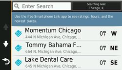
With so much data, nüvi 2789LMT makes it easy to find addresses and millions of POI – that is, businesses, stores, restaurants or other destinations. Our POI database also includes accurate, relevant information sourced from Foursquare. Now, when you search, the most relevant Foursquare result appears at the top of the list. It’s an easy way to discover new and popular restaurants, shops and more.

When you use the Smartphone Link app with your nüvi 2789LMT, you can also check-in on Foursquare and access more detailed information about the POI, including ratings, price range and hours of service.
Free Lifetime Traffic Avoidance
traffic.jpg

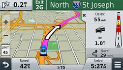
nüvi 2789LMT features Garmin traffic to help you spend more time on the move. With Garmin traffic, your driving map remains onscreen at all times. Traffic alerts appear to the side of your map and messages are spoken, too. Garmin traffic can give details about the situation, such as how many minutes of delay to expect and if there are any possible detours. It can even confirm whether or not you are on the fastest route. Lifetime traffic² entitles your nüvi 2789LMT to receive free traffic information for its useful life, with no ads and no subscription fees. Garmin traffic is delivered straight to your nüvi – no smartphone needed.
Garmin Real Directions™
voice-directions.jpg

Drive with confidence, even when you’re out of cell phone range. nüvi 2789LMT is dedicated automotive navigation that does not rely on cellular signals and is unaffected by cellular dead zones.

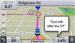
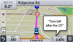
nüvi 2789LMT redefines “spoken turn-by-turn directions” with Garmin Real Directions, easy-to-understand driving directions that guide like a friend, using recognizable landmarks, buildings and traffic lights. No more stress from trying to read street names. Instead, hear clearly spoken guidance, like “Turn left after the gas station.”
Find Exactly Where You Need to Go
direct-access.jpg

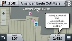
The Direct Access feature simplifies navigating to select complex destinations, like airports and shopping malls, by finding a place within a larger location. When navigating to the mall, Direct Access gives additional location information for specific retail stores inside. For example, "Arriving at Woodfield Mall. Anthropologie is inside, on the upper level." Direct Access even navigates through parking lots to find the entrance nearest your destination.
Easily Navigate Complex Interchanges
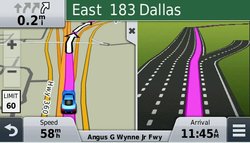
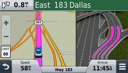
Active Lane Guidance with voice prompts prepares you to drive through an exit or interchange with confidence. As you approach, an animated model uses brightly colored arrows to indicate the proper lane needed for your route; a friendly voice offers additional help. Bird’s Eye junction view offers a detailed view of interchanges, looking down as if from overhead. photoReal Junction View realistically displays junctions and interchanges along your route, including the surrounding landscape. Brightly colored arrows indicate the proper lane to drive. nüvi 2789LMT also depicts real road signs as they appear along your route.

active-lane-guidance.jpg birdseye.jpg photo-real-junction-view.jpg
Bluetooth® Compatible
bluetooth.jpg

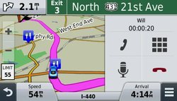
Sync a Bluetooth-enabled device³, such as your smartphone, to nüvi 2789LMT for hands-free calling through its integrated microphone and speaker. Stow your phone in your pocket, purse or console and still make and take calls.
The Power of Your Voice
voice-nav.jpg

nüvi 2789LMT has the luxury of voice-activated navigation. Speak, and your device intelligently responds; your hands can remain on the wheel. Of course, you can also navigate using the touchscreen interface.
Smartphone Link Compatible
smartphone-link.jpg

Smartphone Link is a free mobile app that connects your nüvi 2789LMT with your iPhone® or Android™ smartphone. When paired, your nüvi can use your phone’s existing data plan4 to share information – such as where you parked, POIs and your destination. With the Smartphone Link app, you can conveniently send locations and addresses from your phone straight to your nüvi.

Smartphone Link also gives you access to Garmin Live Services5, useful real-time information such as weather. Smartphone Link works with iPhone 4S or later and some Android devices.
More Information At a Glance
up-ahead.jpg

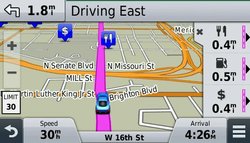
nüvi 2789LMT keeps your driving map onscreen at all times and additional information appears alongside. For details, simply touch the screen. As you drive your route, Up Ahead constantly informs you of nearby services, including food, fuel and ATMs.

nüvi 2789LMT displays speed limit, current speed and estimated time of arrival. With a quick glance, you can read the name of your current street. nüvi 2789LMT also provides school zone alerts.

backup-camera.jpg
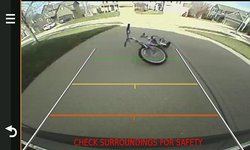
Add a Wireless Backup Camera
For a complete navigation solution, nüvi 2789LMT pairs with the BC™ 30 wireless backup camera (sold separately. Professional installation recommended). Once connected, you can easily see vehicles, pedestrians and other obstacles right on the nüvi display, as you move in reverse.


¹Lifetime Maps Terms & Conditions
²Lifetime Traffic Terms & Conditions
³Requires Bluetooth®-enabled smartphone (sold separately)
4User’s data plan charges, if any, will apply. Contact your mobile service provider for more information about your service plan’s data and roaming rates.
5Subscription may be required.

The Bluetooth® word mark and logos are owned by the Bluetooth SIG, Inc. Foursquare® is a registered trademark of Foursquare Labs, Inc.
here.jpg
 
Last edited:
Here is a good overview of how it works, Now notice in the upper left top corner a graphics bar in green. That is how many sats you are connected to.
Not cell towers but satellites that it is linked to. When you start using it and learning just what it can do you will find it does have wifi and you don't need a smart phone to use it. It simply finds any wifi in that area and linkes to it automatically. It's sat nave not cell nav or it can be both.

View: https://www.youtube.com/watch?v=Dlx3Cjv_OE0
 
Wow. I read the first couple of posts on VDJ7.4.7 and jumped ahead to the last page and we're on GPS devices? Now that thar is sum tangenting.

Ever get the VDJ issue solved?

I have VDJ 7.4.7 and VDJ 2020 (both pro editions) running concurrently. There are features I love about both. To me, the key to VDJ 2020 is a highly flexible, completely customizable skin, and that, friends, would be V8 by FRuit. Connecting my DJM-5000 to my laptop via the USB is all that's needed.

Now if it's just the home version being sought after to use, there's little advice or sympathy that can be offered. I started using VDJ Pro at Version 3.0 and haven't paid a nickel for updates and upgrades since.
 
I don't think I'm interesting enough that anyone would track me and if they did they would likely give up after my third trip to Tim Hortons that day ;)

Hank has your answer there Rockit is as good as anything for what you want.

If you are happier with VDJ you CAN make a playlist with the free version I'm sitting in front of it right now. Go to the right hand side there are tabs click the automix one and the browser appears. Play the first song on whatever deck and right click the second for mix next. Make sure auto is turned on

VDJ2.jpegVDJ1.jpeg
 
I guaranty you it both transmits and receives. You can argue all you want but I have 2 of these and yes they both do transmit and receive in real time. Even when I am out of cell range. In fact when you power it up it tells you it is acquiring satellites and it has an icon that tells you how many sats it's talking to. It need 3 to work but it can link up to 5 sats and it has an icon that shows you how many sats your connected to. If you bother to read the advertisement, it tells you it does not use cell towers. But you didn't read and you don't have one do you?
Advanced GPS Car Navigation
  • 7-inch pinch-to-zoom display
  • Detailed maps of North America with free lifetime¹ map updates and traffic avoidance²
  • Find new and popular restaurants, shops and more with Foursquare®
  • Bluetooth® technology for hands-free calling³
  • Voice-activated navigation allows you to keep your hands on the wheel
Bright Display
nüvi 2789LMT has a bright 7-inch display with pinch-to-zoom capability, so you can quickly get a closer look at any onscreen information.
Detailed Maps with Free Updates
nüvi 2789LMT arrives loaded with detailed maps of North America. With free lifetime¹ map updates, your routes are sure to reflect the most up-to-date maps, points of interest (POI) and navigation information available. New maps are available for download for the useful life of your GPS device, with no fees.
Foursquare Adds Millions of New POIs
View attachment 50380
With so much data, nüvi 2789LMT makes it easy to find addresses and millions of POI – that is, businesses, stores, restaurants or other destinations. Our POI database also includes accurate, relevant information sourced from Foursquare. Now, when you search, the most relevant Foursquare result appears at the top of the list. It’s an easy way to discover new and popular restaurants, shops and more.

When you use the Smartphone Link app with your nüvi 2789LMT, you can also check-in on Foursquare and access more detailed information about the POI, including ratings, price range and hours of service.
Free Lifetime Traffic Avoidance
View attachment 50381

nüvi 2789LMT features Garmin traffic to help you spend more time on the move. With Garmin traffic, your driving map remains onscreen at all times. Traffic alerts appear to the side of your map and messages are spoken, too. Garmin traffic can give details about the situation, such as how many minutes of delay to expect and if there are any possible detours. It can even confirm whether or not you are on the fastest route. Lifetime traffic² entitles your nüvi 2789LMT to receive free traffic information for its useful life, with no ads and no subscription fees. Garmin traffic is delivered straight to your nüvi – no smartphone needed.
Garmin Real Directions™
View attachment 50382

Drive with confidence, even when you’re out of cell phone range. nüvi 2789LMT is dedicated automotive navigation that does not rely on cellular signals and is unaffected by cellular dead zones.

nüvi 2789LMT redefines “spoken turn-by-turn directions” with Garmin Real Directions, easy-to-understand driving directions that guide like a friend, using recognizable landmarks, buildings and traffic lights. No more stress from trying to read street names. Instead, hear clearly spoken guidance, like “Turn left after the gas station.”
Find Exactly Where You Need to Go
View attachment 50383

The Direct Access feature simplifies navigating to select complex destinations, like airports and shopping malls, by finding a place within a larger location. When navigating to the mall, Direct Access gives additional location information for specific retail stores inside. For example, "Arriving at Woodfield Mall. Anthropologie is inside, on the upper level." Direct Access even navigates through parking lots to find the entrance nearest your destination.
Easily Navigate Complex Interchanges
Active Lane Guidance with voice prompts prepares you to drive through an exit or interchange with confidence. As you approach, an animated model uses brightly colored arrows to indicate the proper lane needed for your route; a friendly voice offers additional help. Bird’s Eye junction view offers a detailed view of interchanges, looking down as if from overhead. photoReal Junction View realistically displays junctions and interchanges along your route, including the surrounding landscape. Brightly colored arrows indicate the proper lane to drive. nüvi 2789LMT also depicts real road signs as they appear along your route.

View attachment 50384 View attachment 50385 View attachment 50386
Bluetooth® Compatible
View attachment 50387

Sync a Bluetooth-enabled device³, such as your smartphone, to nüvi 2789LMT for hands-free calling through its integrated microphone and speaker. Stow your phone in your pocket, purse or console and still make and take calls.
The Power of Your Voice
View attachment 50388

nüvi 2789LMT has the luxury of voice-activated navigation. Speak, and your device intelligently responds; your hands can remain on the wheel. Of course, you can also navigate using the touchscreen interface.
Smartphone Link Compatible
View attachment 50389

Smartphone Link is a free mobile app that connects your nüvi 2789LMT with your iPhone® or Android™ smartphone. When paired, your nüvi can use your phone’s existing data plan4 to share information – such as where you parked, POIs and your destination. With the Smartphone Link app, you can conveniently send locations and addresses from your phone straight to your nüvi.

Smartphone Link also gives you access to Garmin Live Services5, useful real-time information such as weather. Smartphone Link works with iPhone 4S or later and some Android devices.
More Information At a Glance
View attachment 50390

nüvi 2789LMT keeps your driving map onscreen at all times and additional information appears alongside. For details, simply touch the screen. As you drive your route, Up Ahead constantly informs you of nearby services, including food, fuel and ATMs.

nüvi 2789LMT displays speed limit, current speed and estimated time of arrival. With a quick glance, you can read the name of your current street. nüvi 2789LMT also provides school zone alerts.

View attachment 50391
Add a Wireless Backup Camera
For a complete navigation solution, nüvi 2789LMT pairs with the BC™ 30 wireless backup camera (sold separately. Professional installation recommended). Once connected, you can easily see vehicles, pedestrians and other obstacles right on the nüvi display, as you move in reverse.


¹Lifetime Maps Terms & Conditions
²Lifetime Traffic Terms & Conditions
³Requires Bluetooth®-enabled smartphone (sold separately)
4User’s data plan charges, if any, will apply. Contact your mobile service provider for more information about your service plan’s data and roaming rates.
5Subscription may be required.

The Bluetooth® word mark and logos are owned by the Bluetooth SIG, Inc. Foursquare® is a registered trademark of Foursquare Labs, Inc.
View attachment 50392
I guarantee you it has a GPS receiver and has NO transmission capabilities. Being 'connected' to 4 satellites literally means it's received a signal from 4 satellites - that's all. As posted before from someone else, the 4th is usually for height/elevation information. The 4th just makes everything a little more accurate. Don't believe me, call them. These devices are receive only. Do you know how many problems there would be if someone could simply take a $200 GPS unit and hack all of our satellites with it? You admit that you're all about the old school stuff. Kinda hard to know about new school then. It's even harder when you refuse to hear what's being said.

It's all good man. Keep on, keepin' on. :)
 
Last edited:
  • Like
Reactions: Jeff Romard
You didn't read the add for the device did you.

Garmin Real Directions™

View attachment 50379


Drive with confidence, even when you’re out of cell phone range. nüvi 2789LMT is dedicated automotive navigation that does not rely on cellular signals and is unaffected by cellular dead zones.
Triangulation referred to OnStar. As I stated, it would be really odd if they were not using it. Seems it was you that you didn't read. Additionally, no device can connect to any wifi automatically - unless it is an unsecured wifi, which you would NOT want it to connect to anyways. You're worried about being tracked and all .. yet everything you say really makes you more vulnerable (unsupported OS and devices, randomly connect to unsecured wifi, etc). You may want to read up on how things actually work - so that you have a better understanding of what they do and how you can better protect yourself.

Again, it's all good man. Keep on, keepin' on. :)
 
Last edited:
Back on topic:

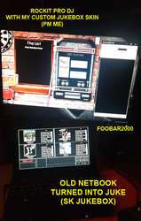
1. IMO, the only free personal jukebox software you'll ever need is SK Jukebox.

2. For a simple substitute of any on board player, I suggest Foobar200

3. Rockit Pro DJ (PM me)

View attachment 50403


I can get vdj2020 to work but I can't find in the settings how to build a set list and have it play one song after another. It just plays one song at a time then you have to drag and drop another song in the player and hit play. I looked in the settings but can't find a way to build a set list so I can just hit play once and walk away and let it plat through that set list. I have also not tried assigning the output to come out a USB port instead of off the 1/8th audio jack off the mother board. Theres surly a setting in the menu somewhere but I havent found it yet. But to be honest I haven't had time to mess with it much.
 
I don't think I'm interesting enough that anyone would track me and if they did they would likely give up after my third trip to Tim Hortons that day ;)

Hank has your answer there Rockit is as good as anything for what you want.

If you are happier with VDJ you CAN make a playlist with the free version I'm sitting in front of it right now. Go to the right hand side there are tabs click the automix one and the browser appears. Play the first song on whatever deck and right click the second for mix next. Make sure auto is turned on

View attachment 50404View attachment 50405


Thank you very much. I found the icon and have auto mix now. Thank you for scream shoting the player so I could find the icon.. Now Is there a way you get the output to run through a USB port so I can run a USB to my DJM5000?
 
  • Like
Reactions: Jeff Romard
Thank you very much. I found the icon and have auto mix now. Thank you for scream shoting the player so I could find the icon.. Now Is there a way you get the output to run through a USB port so I can run a USB to my DJM5000?

I haven't actually tried it but in settings/audio settings there is an option for a USB soundcard. I don't use VDJ often except for video my weapon of choice is Mixmeister Pro so I'm learning as I go here
 
  • Like
Reactions: oldschool
I haven't actually tried it but in settings/audio settings there is an option for a USB soundcard. I don't use VDJ often except for video my weapon of choice is Mixmeister Pro so I'm learning as I go here

Yes I see where it says usb out but it wont let me use it. I found auto settings and where it says hardware. It gives me a choice of speaker out only, then below tha speaker headphone, than below that separate decks. In the middle it says heard wear, it give 3 choices computer out, stereo out, and usb sound card out. USB sound card is highlighted in blue but no sound coming out of usb. Even after I hit apply.
 
Now Is there a way you get the output to run through a USB port so I can run a USB to my DJM5000?
Probably not on the free "Home" version - as soon as you start using external hardware, I think you'll need to upgrade to the $$$$$$ version for it to work.
At the very least, you'll need the DJM-5000 Windows Driver loaded, but again, I'm not sure if the unpaid version is going to work -
 
  • Like
Reactions: oldschool
Probably not on the free "Home" version - as soon as you start using external hardware, I think you'll need to upgrade to the $$$$$$ version for it to work.
At the very least, you'll need the DJM-5000 Windows Driver loaded, but again, I'm not sure if the unpaid version is going to work -


Thanks so much. I hadn't thought that this pc didn't have DJM5000 soft wear installed. I installed it and BINGO we have lift off!!!
Thanks a lot for walking me through this.
Thanks again man for taking the time to actually help me. :wave:
 
  • Like
Reactions: Handinon
I haven't actually tried it but in settings/audio settings there is an option for a USB soundcard. I don't use VDJ often except for video my weapon of choice is Mixmeister Pro so I'm learning as I go here

And thank you Jeff, both you and Handinon got me up and running. Thanks to the both of you.
 
  • Like
Reactions: Jeff Romard
Probably not on the free "Home" version - as soon as you start using external hardware, I think you'll need to upgrade to the $$$$$$ version for it to work.
At the very least, you'll need the DJM-5000 Windows Driver loaded, but again, I'm not sure if the unpaid version is going to work -


Handinon: I had totally forgot this pc didn't have DJM5000 drivers installed. I installed them and it works perfectly. It's been years since I set up my old pc I forgot about the drivers. You have my respect for reminding me and taking the time to help me.

JeffRomard, A big thanks to you for helping me find the auto mix icon so now I'm up and running with auto play on the player.
I tend to forget that these things need drivers and there are so many Icons in windows, sometimes there hard to find when you don't use them on a regular bassos, you tend to forget. . You were both a big help. These computers have so many options and configurations that it's just a matter of finding the ones that will make your equipment work properly. I tend to not just start pushing icons because I have crashed my pc more then you know and to remember what you did and how to undo it, if you make a mistake so I don't just apply settings when I don't know what the result will be.
The old saying goes use it or lose it really applies when there are so many options to work with.
Thanks again for setting me strait and being so much help. I have my juke box working through my usb thanks to the both of you. I owe both of you a beer or big fatty what ever your preference are. But a big thanks will have to do for now.
Now I just need a longer usb cord to reach my daily pc to run to my mixer.

You both were helpful and stuck with me. My respects to the both of you.
 
  • Like
Reactions: Jeff Romard
Triangulation referred to OnStar. As I stated, it would be really odd if they were not using it. Seems it was you that you didn't read. Additionally, no device can connect to any wifi automatically - unless it is an unsecured wifi, which you would NOT want it to connect to anyways. You're worried about being tracked and all .. yet everything you say really makes you more vulnerable (unsupported OS and devices, randomly connect to unsecured wifi, etc). You may want to read up on how things actually work - so that you have a better understanding of what they do and how you can better protect yourself.

Again, it's all good man. Keep on, keepin' on. :)


It true these devices can be tracked, but if they don't know who owns them or using them they can't trace it to a specific person.Now when you buy these devices with a credit card or supply your actual personal information, there linked to who bought them but if you buy them second hand or don't supply your personal info, there just devices that are moving around but they don't know who is using them but just that there being used.
It's all good,, no worries on my side, we just have differing opinions sometimes. Nothing wrong with that, Everyone is free to have there own opinion about everything. As long as one is respectful, I hold no grudges. No one can know everything and everyone has different skill sets. Thats why it's important to suround yourself with people of all knowledge's and skill sets
 
Last edited:
  • Like
Reactions: Cap Capello